News Release from GEO-NET Umweltconsulting GmbH
Wind Industry Profile of
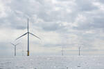
200 m reference wind measuring mast for research, development and LiDAR verification by GEO-NET near Hanover
Bigger, higher, stronger - what applies to sport also applies to the wind industry. With greater hub heights, larger rotors and more powerful generators, wind turbines are becoming ever more efficient, wind power ever cheaper, and thus wind energy is making an increasingly important contribution to climate protection and security of supply.
With hub height, rotor diameter and turbine capacity, of course, the challenges also grow, and not only during the construction of the turbines or their operation, but already in the early planning phase - for example with yield assessments and wind measurements. To keep uncertainties as low as possible, a yield assessment needs reference data on wind speed as close as possible to the planned hub height. Many existing turbines are now too low compared to the current turbine generations, so that a wind measurement becomes necessary to gain reliable reference data. For reasons of cost and time, LiDAR devices are now often used for this purpose, which in turn must be verified on a reference mast - and also as close as possible to the planned hub height. And it is precisely for this purpose that the wind experts from GEO-NET have now installed a 200 m high wind measuring mast close to Hanover for the verification of LiDAR and SoDAR.
The relevant standards TR6 and MEASNET require a measurement on 2/3 and a verification on at least three quarters of the planned hub height. However, uncertainties can be further reduced by a higher measurement, which of course must also be verified at the corresponding height. In addition, more data is obtained over a larger part of the rotor circle - which is particularly interesting for large rotors, since here the wind shear provides for sometimes strongly varying wind conditions and thus additional loads between the upper and lower rotor ends.
GEO-NET's location offers numerous advantages: It is centrally located, easy to reach via the A2, A7 and A27 motorways, and offers good wind conditions. This means that GEO-NET can carry out the verification more quickly and the verified devices can start the actual measurement earlier. The site has a free flow in the relevant sectors and, in contrast to coastal sites, is more representative of inland sites, as wind shear, turbulence and precipitation in particular are comparable, which in turn reduces uncertainties in the yield assessment. The reference mast is equipped with special instrumentation for measuring turbulence and meteorological parameters in order to use the measurement data for various research and development projects in the fields of wind energy, meteorology and climatology. In these areas, GEO-NET is already working closely and successfully with Leibniz Universität Hannover and Fraunhofer IWES in the joint projects EWiNo, SUnDAY and ADLER.
GEO-NET offers verification at fixed prices as well as in complete packages with wind measurement campaign, yield and turbulence assessments, always focusing on the smooth and time-optimized implementation of the entire package.
GEO-NET is independent, internationally accredited and keeps these accreditations up to date. The equipment verified by GEO-NET can be used for bankable wind measurement campaigns and yield assessments, helping to reduce uncertainties and thus enabling the financing of certain projects in the first place.
In this way, GEO-NET already makes an important contribution to climate protection and security of supply in the project planning phase.
- Source:
- GEO-NET
- Author:
- Press Office
- Link:
- www.geo-net.de/...
- Keywords:
- GEO NET, measuring mast, LiDAR, development, research, hub height, wind speed, data, planning, turbine generation