News Release from windfair.net
Wind Industry Profile of
Ireland: Carbon Trust launches world’s largest technology trial to create 3D wind maps for offshore wind farms
This is the latest Offshore Wind Accelerator (OWA) project designed to help reduce the cost of energy from offshore wind.
Over the next three months the most comprehensive test of scanning LIDAR technology will take place, where four different scanning LiDAR systems will be put through their paces, alongside three vertical profiling LiDARs for validation purposes. The project is being supported by independent renewable energy company, RES and maritime safety organisation, Commissioners of Irish Lights.
Accurate wind resource measurements are critical to wind farm development because they are used to calculate the potential energy yield from a wind farm, which dictates the terms of the project financing. This can be a significant proportion of the overall project cost, accounting for around 45 percent for an average wind farm.
Scanning LiDAR is not a new technology. Conventionally, it is used by the defence and aerospace industries to monitor for oncoming weather fronts. But it does not have a proven track record in offshore wind.
 Normally wind resource is measured using large steel towers called met masts, which require a large capital investment (£10-£12m) incurred at risk before a project gets the go ahead adding significant upfront costs, which could inhibit the exploration of new sites. The OWA project aims to test how accurately scanning LiDAR technology can measure wind resource for potential wind farm sites, which could deliver significant cost savings in the early stages of wind farm development.
The OWA has been working for the past few years to support more cost effective solutions, focusing on the development and commercialisation of a number of floating LiDAR systems, to significantly reduce upfront capital expenditure. Yet measurements taken by both masts and floating LiDAR are limited in that they only provide a measurement of the wind resource at a single point in space. For an offshore wind farm covering an area of up to 200 square kilometres, this can create uncertainty on the wind speed at locations far from the measurement point. This is known as spatial variation, where measurements may not representative of the entire site. This is translated into risk incurring additional financing costs to wind farm development.
Scanning LiDAR technology has the potential to reduce the risk associated with spatial variation. These systems are capable of scanning with a usable range of between 10 to 30 kilometres, to impressive levels of detail, taking over 100 measurements per minute. This allows developers to build a much more detailed picture of a site, not only significantly reducing uncertainty of spatial variation, but also allowing developers to better plan the layouts of the turbines to best exploit the individual wind conditions at the site. Increasing confidence on spatial variation could reduce risk to minimal levels, which can save millions of pounds on a project and reduce the cost of energy from offshore wind.
A difference of only 0.2 mph in wind speed can result in significant variation of yield calculations over the lifetime of a wind farm. It is therefore critical that the industry has confidence in scanning LiDAR devices being sensitive enough to detect such small variations. The OWA trial aims to test the sensitivity of the devices to picking up these variations in wind resource.
The units involved in the trial are:
- 3 Leosphere WINDCUBE vertical profiling LiDARs
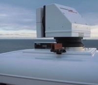
- 1 Leosphere WINDCUBE 400S scanning LiDAR
- 1 Leosphere prototype scanning LiDAR
- 2 Lockheed Martin WindTracer scanning LiDARs
Megan Smith, Project Manager, Wakes Research at the Carbon Trust commented: “Many factors can impact available wind resource at a potential wind farm site including its proximity to shore, neighbouring wind farms, and as a result of tidal currents. This project forms a really important stage of the OWA’s efforts to increase the industry’s understanding of wind resource measurement and validate the technologies capable of delivering results. Project financing is a significant proportion of cost, so anything we can do to get a deeper understanding of yield will increase investor confidence and lower the cost of financing. Scanning LIDAR has the potential to take our understanding to a completely new level. In information terms it is the difference between taking a still photo compared to having a three dimensional video with full sound. The need to test the sensitivity of the technology is the next frontier in getting industry acceptance.”
“This is an ambitious project and has relied on a range of key partners including RES, Irish Lights and the technology developers, Leosphere and Lockheed Martin to get it successfully off the ground. We are looking forward to seeing what results and will be sharing them with the wider industry in due course.”
 Simon Feeney, Commercial Manager for Measurement Services at RES commented: “RES is delighted to support the Carbon Trust and OWA in delivering this challenging and ground-breaking project. RES believes scanning LiDAR has the potential to radically change the approach to wind resource assessment for developers of offshore wind.”
Welcoming the announcement, Dave Ward, Commercial Services Manager at Irish Lights said: “Irish Lights is delighted to be associated with the Carbon Trust’s scanning LiDAR technology testing platform in Dublin Bay. It has been a great opportunity for us to leverage our expertise, experience and assets to support RES and their partners with advice and support on site selection, calibration, assembly and data streaming building on our own successful Dublin Bay Digital Diamond project which focuses on delivering offshore data and communications services. We recognise that every developing industry has its own unique suite of supply chain inputs which in their own right create spin off opportunities and we are excited about the potential of this test platform to strengthen innovation and collaboration in the offshore energy development.”
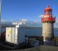
Video of the Leosphere windcube 400s being installed at the Baily lighthouse on the north side of Dublin Bay:
- Source:
- Carbon Trust
- Link:
- www.carbontrust.com/...
